Log in
All resources
Create a design
9,296 Free Artworks of Map Collection
bibliothèque nationale de france
vrbivm praecipvarvm mvndi theatrvm qvintvm (1617)
national library of poland
chorographia britanniae (1741-1742)
paper
eran laor cartographic collection
maps by willem and johannes blaeu
british library
british museum
british library - off the map alice collection
british library - off the map alice collection - wonderland
british library - off the map alice collection
british library - off the map alice collection - wonderland
british library - off the map alice collection
british library - off the map alice collection - wonderland
british library - off the map alice collection
british library - off the map alice collection - wonderland
british library - off the map alice collection
british library - off the map alice collection - wonderland
british library - off the map alice collection
collections of archives départementales de la marne
postcards of marne
19th-century maps of lyon
guides joanne
maps in the stadsarchief amsterdam
daniel stoopendaal
maps from gallica
maps of antwerp
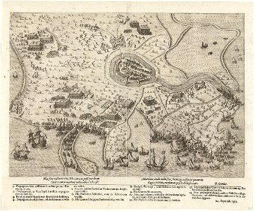
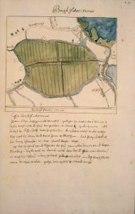
siege of hulst 1591
old maps of hulst
civitates orbis terrarum. contrafactur und beschreibung von den vornembsten stetten der welt. liber tertius
maps of philippeville by braun & hogenberg
civitates orbis terrarum. contrafactur und beschreibung von den vornembsten stetten der welt. liber tertius
maps of arnhem by braun & hogenberg
civitates orbis terrarum. contrafactur und beschreibung von den vornembsten stetten der welt. liber tertius
maps of fortress of charlemont by braun & hogenberg
geographia universalis (1545) in the british museum
german renaissance,northern renaissance
drawings in the stadsarchief amsterdam
johan martinus anthon rieke
eran laor cartographic collection
willem albert bachiene
chorographia britanniae (1741-1742)
18th-century maps of westmorland
prints in the british museum
jacob folkema
chorographia britanniae (1741-1742)
18th-century maps of monmouthshire
prints in the british museum
jacob folkema
1630s maps of ethiopia
1635 maps of africa
chorographia britanniae (1741-1742)
18th-century maps of northumberland
map of ancient armenia by philippe de la rué
maps of antony's parthian war
18th-century maps of huntingdonshire
chorographia britanniae (1741-1742)
prints in the british museum
jacob folkema
18th-century maps of nottinghamshire
chorographia britanniae (1741-1742)
17th-century maps of poitou
1660s maps of france
chorographia britanniae (1741-1742)
18th-century maps of cambridgeshire
chorographia britanniae (1741-1742)
18th-century maps of middlesex
chorographia britanniae (1741-1742)
18th-century maps of cumberland
18th-century maps of england and wales
chorographia britanniae (1741-1742)
eran laor cartographic collection
braun/hogenberg dreizehn orte
prints in the yale center for british art
william bernard cooke
eran laor cartographic collection
18th-century maps of jerusalem
maps in the stadsarchief amsterdam
daniel stoopendaal
dutch baroque architecture
nieuwe kerk, haarlem
satirical prints in the british museum
works after robert dighton
lord burghley's atlas (1579) - bl royal ms 18 d iii
maps of wales by humphrey llwyd
maps by willem and johannes blaeu
1690s maps of indonesia
17th-century maps of the indian ocean
maps by willem and johannes blaeu
maps by willem and johannes blaeu
1690s maps of indonesia
maps of the course of the rhine by guillaume sanson
bibliothèque nationale de france
sanson maps of south america
1719 maps of south america
bibliothèque nationale de france
sanson map of lorraine
renold elstracke
renaissance
drawings in the metropolitan museum of art
jan anthonie coxie
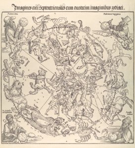
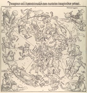
the northern hemisphere of the celestial globe by albrecht dürer
german renaissance
the northern hemisphere of the celestial globe by albrecht dürer
german renaissance
high renaissance,renaissance
codex windsor
prints by oluf olufsen bagge in the statens museum for kunst
etching print
1750s maps of saxony
old maps of leipzig
old maps of gdańsk
baroque
prints by mary cassatt in the metropolitan museum of art
impressionism
17th-century maps of europe
maps by carolus allard
maps by willem and johannes blaeu
old maps of gâtinais and sénonais
17th-century maps of the holy roman empire
maps by pieter van der keere
maps of cyprus by mercator-hondius
eran laor cartographic collection
robert cordier (engraver)
1789 maps of france
robert cordier (engraver)
1789 maps of france
atlas schoemaker-noord-holland, amsterdam
buikslotermeer
eran laor cartographic collection
gerard de jode
charles william meredith van de velde
eran laor cartographic collection
portraits by charles-philippe larivière
neoclassicism
topographia braunschweig lüneburg (merian)
baroque
eran laor cartographic collection
cornelis danckerts (ii)
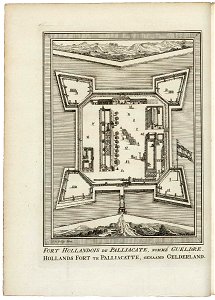
maps of lisbon by braun & hogenberg (1572)
maps of cascais by braun & hogenberg
bibliothèque nationale de france
maps by thomas kitchin
maps in the stadsarchief amsterdam
hendrik de leth
maps in the stadsarchief amsterdam
hendrik de leth
maps in the stadsarchief amsterdam
hendrik de leth
maps of the dutch east india company - india
1755 maps
maps of ancient italy by philipp clüver
old maps of samnium
19th-century maps of maastricht
maps in hcl (maastricht)
19th-century maps of maastricht
maps in hcl (maastricht)
german renaissance,northern renaissance
prints in the british museum
shan shui paintings in the national palace museum
zhao boju
eran laor cartographic collection
claes jansz. visscher (ii)
john rocque's 1748 map of london and adjacent country
remigius parr
sanson maps of the holy land
old maps of canaan
maps by pieter mortier
maps from gallica
admiranda narratio, fida tamen, de commodis et incolarvm ritibvs virginiae anglico scripta sermone à thoma hariot nvnc avtem primvm latio donata à c.c.a (1608)
theodor de bry
maps of the course of the rhine by guillaume sanson
maps by nicolas sanson
maps by isaak tirion
old maps of haarlem
petit atlas pittoresque des 48 quartiers de la ville de paris, bhvp
paris former 4e arrondissement
petit atlas pittoresque des 48 quartiers de la ville de paris, bhvp
paris former 4e arrondissement
prints by matteo greuter in the statens museum for kunst
copper
vrbivm praecipvarvm mvndi theatrvm qvintvm (1617)
maps of castelnuovo by braun & hogenberg
vrbivm praecipvarvm mvndi theatrvm qvintvm (1617)
maps of cártama by braun & hogenberg
vrbivm praecipvarvm mvndi theatrvm qvintvm (1617)
maps of acquapendente by braun & hogenberg
vrbivm praecipvarvm mvndi theatrvm qvintvm (1617)
maps of zahara by braun & hogenberg
vrbivm praecipvarvm mvndi theatrvm qvintvm (1617)
maps of lyon by braun & hogenberg
historical images of dubrovnik
baroque
vrbivm praecipvarvm mvndi theatrvm qvintvm (1617)
maps of montlhéry by braun & hogenberg
vrbivm praecipvarvm mvndi theatrvm qvintvm (1617)
maps of münstermaifeld by braun & hogenberg
vrbivm praecipvarvm mvndi theatrvm qvintvm (1617)
maps of sarrebourg by braun & hogenberg
robert gordon of straloch
old maps of sutherland
vrbivm praecipvarvm mvndi theatrvm qvintvm (1617)
maps of hildesheim by braun & hogenberg
vrbivm praecipvarvm mvndi theatrvm qvintvm (1617)
maps of tours by braun & hogenberg
vrbivm praecipvarvm mvndi theatrvm qvintvm (1617)
maps of tønder by braun & hogenberg
vrbivm praecipvarvm mvndi theatrvm qvintvm (1617)
maps of husum by braun & hogenberg
4601 - 4700 of 9,296
Next page
/ 93